Zazzle Shop

Screen printing
Showing posts with label GPS Navigation. Show all posts

Thursday, March 10, 2011

Google Maps Navigation Gains Real-Time Traffic Re-Routing

Traffic. Just the mention of the word makes some city folk cringe, and for most everyone, it turns a good day into a bad one. It's a dreadful thing, and it's something that some people have to deal with on a daily basis. But technology has been coming to the rescue lately, with many personal navigation devices adding real-time traffic alerts to keep motorists from falling into nasty log-jams that are near impossible to escape.

Google is a bit behind when it comes to that, but when the app is free, who could complain? Google Maps 5.2.1 introduces a killer new feature: real-time traffic alerts. The new version of the app has the ability to route users around traffic, and with over 35 million miles driven by Google Maps Navigation users every single day, it should end up being quite effective. The traffic data is crowdsourced; if you're using Google Maps Navigation to get around, your velocity and location can be recorded and sent to show others in general how fast a given road is.
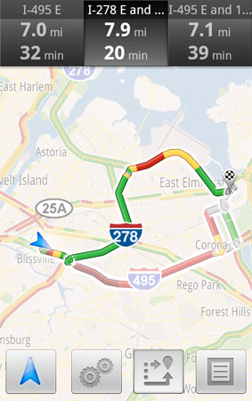

You don’t have to do anything to be routed around traffic; just start Navigation like you normally would, either from the Navigation app or from within Google Maps. Before today, Navigation would choose whichever route was fastest, without taking current traffic conditions into account. It would also generate additional alternate directions, such as the shortest route or one that uses highways instead of side roads. Starting today, our routing algorithms will also apply our knowledge of current and historical traffic to select the fastest route from those alternates. That means that Navigation will automatically guide you along the best route given the current traffic conditions.

Sounds like a total winner to us, and we hope it spreads to more navigation systems soon. Thanks again to Google for pushing competition.

Thursday, February 24, 2011

How your smartphone's GPS can get out of a speeding ticket


AOL Original Content by Damon Lavrinc
from: http://translogic.aolautos.com/

Motorola Droid with MyTracks App

We've all have that friend-of-a-friend-of-a-friend who fought the law over an erroneous speeding ticket, but do you know anyone who's put their smartphone on the stand to prove their innocence? Well, you do now.

Sahas Katta got clocked by a cop doing over 40 in a 25 mph zone. He handed over his info and signed the ticket, but then remembered he was running Google MyTracks on his Motorola Droid. For the uninitiated, MyTracks is an Android app that uses the phone's GPS to record and plot where the user has travelled, allowing you to log a jog, bike ride or drive. After looking at the data and doing some research, Katta discovered that he never crested the 25 mph speed limit and decided to fight the ticket.

You can read the entire account over at SkatterTech, but for the tl;dr crowd, the cop didn't know the last time he went through radar training, when the gun was serviced or the unit's model number. OutFrontKatta then busted out the GPS data from his Droid, and after reviewing the evidence and Katta's clean driving record, the judge let him off. Granted, he may have just gotten lucky thanks to a uninformed judge and a hapless cop, but the results all the same. Lesson learned. You can download MyTracks here.

If you're not equipped with one of the dozens of Android-powered smartphones on the market, you've got a few alternatives. For the iPhone crowd, there are a myriad of GPS-tracking apps on the market, including the OutFront and myTracks (no relation to the Google-developed app). If you're packing a new Windows Phone 7 device, the pickings are slightly slimmer, but Marathon is porting over its popular Windows Phone 6 app to the new mobile OS and has included several social features into its updated app. TrackSpace and MojoTracker appears to be the best solution for Palm/HP WebOS devices and for those using a Nokia smartphone SportsTracker looks like the best bet.

Check out a videos demos below to get a taste of of OutFront and Marathon, and submit your own selections in the comments below.


[Source: SkatterTech]

Wednesday, November 17, 2010

Chicago Using GPS-Collared Coyotes to Control Rodents?

by Jaymi Heimbuch
from: http://www.treehugger.com/

coyote in chicago photo
Photo via video from WGN-TV

Most of the time when a city has a rodent problem, they call in human exterminators. But Chicago seems to be testing out something slightly more... natural. After spotting a coyote running down State Street in Chicago, residents became aware of a project the city is testing out that includes allowing GPS-fitted coyotes to run free in the city specifically for them to gobble up problematic pests like rats, mice and rabbits. However, Chicago isn't letting coyotes run all over in order to keep the rat populations down. Rather, there is a much cooler project underway. Video of the wily coyote after the jump.


According to Chicago Breaking News, "Brad Block, a supervisor for the Chicago Commission on Animal Care and Control, said the animal has the run of the Loop to help deal with rats and mice. He said no one has called today to complain.

'He's not a threat...He's not going to pick up your children,' Block said. 'His job is to deal with all of the nuisance problems, like mice, rats and rabbits.'

Block said he believes the coyote is one of those fitted with a GPS device to monitor its whereabouts. He said the coyote is pretty timid and stays away from people."

Gizmodo jumps to another conclusion, stating, "Chicago police said they hadn't heard anything about any coyotes--but now the Chicago Commission on Animal Care and Control is saying that it's probably a coyote that was let loose in purpose. To kill rats and stuff."

Rather than let loose on purpose -- which these urban coyotes are not -- the GPS-collared coyotes are part of a project to learn about how the animals fare in urban settings. So, this coyote is likely one from the Urban Coyote Ecology and Management project, which captures coyotes that make their way into urban areas, fits them with radio collars, and re-releases them in order to study them more closely.

It seems smart at first, though seeing a coyote running down the middle of a road highlights a few problems -- how many of these coyotes become roadkill, or eat up someone's house cat while out prowling for pests? Another issue is brought up in the Chicago Breaking News article: "Earlier this year, another coyote was found in a park near the Chicago River and would return there to scavenge for food, he said. That animal had to be removed because it had become accustomed to people and their handouts. It was eventually taken to a wildlife center."

No one really knows what effect city life has on coyotes -- the project says it best themselves:

Our limited understanding of how coyotes succeed in urban landscapes hampers management of this animal. Even knowledge of their basic ecology is incomplete. This is important because diets, social behavior, movement patterns and survival may change with urbanization. Nevertheless, as coyotes become increasingly abundant in the cities, so does the need for basic information to develop management strategies. In areas where coyotes have existed with people for some time, such as the southwestern United States, conflicts with coyotes threaten the health and well-being of people and pets. Are extreme conflicts the inevitable result of the relatively recent emergence of coyotes in Midwestern and eastern U.S. cities? What are the full ramifications for people, pets, and other wildlife when this remarkable canid suddenly becomes a neighbor?

That's the purpose of the experiment -- to find out how coyotes really fare as urban landscapes take over their natural habitat. Since 2008, the project has captured and collared 250 coyotes. Gathering up information by following the animals will help unveil questions such as how big an impact cities have on coyotes, how it might change their behaviors or food sources, and whether or not they're to be the next raccoon, pigeon, skunk or opossum.

As far as a coyote being released on purpose to eat up rodents...well, that's probably more a tactic to keep city residents calm about their furry neighbors. Instead, the animals-as-pest-control is likely more of a happy side effect of letting the coyotes do their thing in order to find out more about them.

Thursday, April 8, 2010

What’s Happened With Cell Phones This Decade?

From: http://cellphones.org/
Posted by: admin

Cell Phones this Decade
Via: Cell Phones

Wednesday, October 28, 2009

Google Maps Navigation: A Free, Ass-Kicking, Turn-by-Turn Mobile App

Google's free turn-by-turn navigation for Maps is the news this morning, and even in Beta, they got a lot right. It has Google tech, like Street View and satellite imagery, and even voice-powered search. Here's what you need to know.

• What's getting it: It's Android OS 2.0 only for now. And will be available when devices like that ship. (Google demo'd the app to us on a Droid, FWIW.) Other platform support will be announced "by carriers and phone makers" when they're ready, but Google implied they are working closely with Apple now on it.
• How you tell it where to go: Addresses are input by either text or voice (using the same tech as in the iPhone's Google mobile app). But the app can take things like business names and restaurant types as well as soft queries like "that museum that has the King Tut exhibit" and return a list of suggested locations
• Traffic handling: The traffic data, as on Google Maps, is driven by multiple sources. Typically, this means data could be from local road authority services like the Bay Area's Caltrans department's highway cameras and services like Inrix, but also from cellphones using Google Maps.
• Price: It's free, and there are no ads. There's nothing like it in Apple's App Store that's less than $25 bucks a year.
• Turn-by-turn voice: There's only one English-speaking voice at the moment, but it does to text-to-speech, reading street names out loud.
• Does it work offline? Sort of. Maps cache along your intended route, so even if your connection dies along the way the route will still show you what you need to see, and text-to-speech voice synthesis of street names still works, too.
• Maps that never age: Like most cloud map services, you'll never need to update your map data, but you have to download route maps every time you head out (so you need cell service at the starting point).
• Unique views: It has satellite view, which is super cool for context on the street, but also, it has Street View. When you're supposed to turn, Street View images come up, overlaid with arrows. Same thing happens at your final destination. Since Street View images have metadata on direction faced and position, Google Maps Navigation intelligently draws the arrows where you're supposed to go. Sort of.
• Traffic UI: The traffic icon is simple—green, yellow and red according to flow of traffic, with your time of arrival next to the symbol. If you click on the traffic icon, the map zooms out to show congestion points along your route.
• Multi-destination routing? There's no way to setup multiple stops to help you plan a day's drive to many locations. But you can search for locations (gas, eateries) along your route, and those results will show up on the map as long as they're within a radius that moves long your path. You can also pre-determine your stops, and quickly queue up the next when you reach each destination.
• Navigate to point on map: You can tell it to navigate to a location by spotting it on a map and holding your finger down on that point.
• OS integration: You can bookmark locations as icons on your Android phone's home page.
• Layers? The data on the map, like traffic, satellite view and points of interest, are called layers. Google said it would be easy for them to add more layers, so its ostensibly possible to add things like Google Latitude support, and other neat tricks. Maybe they'll open up an API for it.
• Different UIs for different usage cases: There's a landscape and portrait mode, as well as a big-icon UI for dashboard usage.
• My fears on zero pricing, for the long term: If Google sells this in the App Store for zero dollars, those millions of bucks Apple makes off of GPS app sales will likely disappear. It's not for us to worry about until there's no more GPS competition except Google, and we're dependent on their pace of progress, but no competition is a bad thing. And it's a little strange that Google's search money is going to pay for a free map app that is competitive with stuff that costs $100 a year from full-time GPS makers like TomTom. Unfair is the word that comes to mind. But I can't say I don't want this app.

A visual tour of Google Maps Navigation:

A Walkthrough of Google Maps Navigation


Send an email to the author of this post at blam@gizmodo.com.

Friday, August 28, 2009

Head to Head Comparison of the 5 Most Popular iPhone Turn by Turn Navigation Apps

Stay tuned for more hacks, tips, jailbreak, how to guides
Subscribe to Our RSS Feed
Follow Us on Twitter
iPhone Apps, iPhone Games promo codes and other products are being given away only via Twitter

Join Our Community or Become a Fan Using Toolbar Below

Iphone_gps

If you haven't heard, the iPhone now supports turn by turn navigation apps. These apps essentially turn your iPhone into one of those portable navigational devices which people refer to as "my navi" or "my GPS". Overall, the apps are quite good. They work well, they look great, and having a turn by turn navigational system on your cell phone is highly convenient. The Palm Pre, unlike the iPhone which requires purchasing an app from the App Store, comes equipped with one of these apps, and it's free with the Sprint service plan. The Pre's app, "Telenav By Sprint", is quite frankly the perfect turn by turn navigational app for a cell phone, and we compared the 5 most popular American navigational iPhone apps to the Pre app.

Look below for a detailed table comparing the applications on 20 different parameters.

Note: For these applications you will 100% need a car charger and an in-car iPhone cradle. These apps drain the iPhone's battery like crazy. Without an in-car iPhone cradle the apps will be pretty much useless. TomTom will soon start selling a car kit which may even be sold as a bundle with the application.


5-most-popular-iphone-turn-by-turn-navigation-apps-review_sm

click to enlarge or click here for full size table

Below are brief overviews of each individual application with screenshots and iTunes links. Please let us know in the comments which app you bought and how it has been working for you.

TomTom (B+)


App Store Link


Tomtom1 Tomtom2 Tomtom3

TomTom is the leader of the GPS world, and there's a reason. They make a good product, and that didn't change for their iPhone app. The app works great. Just like their portable devices, the map itself looks ugly...with a thick red line over a beige background, and occasionally some jagged edges. But quite frankly, it's not there to be modeled, it's there to guide you and give you functionality. That it does.


Navigon MobileNavigator (B)


App Store Link


The Navigon Mobile Navigator may be the best option in the App Store right now due to the fact that it has been dropped to $70 until August 31st, when it will go up to $100. The Navigon app will guide you wonderfully, but there are a few things missing. For one, you can't see the route summary. There's also no traffic feature...but that shouldn't stop you from buying the app.

Navigon1 Navigon2 Navigon3

AT&T Navigator (C+)


App Store Link

Navigator1 Navigator2 Navigator3

The AT&T Navigator application is an excellent app except for 3 things. It requires an internet connection, since the maps are always downloaded fresh from AT&T's servers. That means it takes a while to load and reload. Also, there is no landscape mode, which is silly for a navigational app. Lastly, the $10/month pricing will lead to an extremely expensive application if you keep it for a while. But if you're okay with that, the app offers a vivid and attractive map, and a few other great features: traffic and search for lowest-priced gas.


CoPilot Live North America (C)


App Store Link


Copilot1 Copilot2 Copilot3

CoPilot Live North America is the cheapest of the 5 applications, costing only $35. However, you pay for what you get. Many expected features are missing, and some of the present ones don't work. The POI search, for instance, needs a lot of work. Also, users have been complaining about app stability. On the plus side, if you just need an app to guide you from point A to point B, CoPilot will do the job. And the map looks great.


Sygic Mobile Map US (C)


App Store Link


Sygic


For $40, Sygic Mobile Map US seems like a bargain. However, while the design is quite sharp, this app is lacking when it comes to actually guiding you on the road. The app often takes a while to lock a GPS signal, and often runs slow. While it hasn't happened to me, many users have complained that it has taken them the wrong way. There's also no contact integration. The good thing about this app is that it offers 26 different languages to guide users in.

Wednesday, August 26, 2009

Bob Dylan to become the voice of your GPS satnav?

For anyone lost on their way to Maggie’s Farm, this might be just the thing.

Bob Dylan could soon voice sat nav systems
Bob Dylan could soon be directing drivers down Highway 61as car giants frantically bid to sign him up as the new voice of their sat nav systems

Bob Dylan, the singer-songwriter who has taken his fans down Highway 61 by way of Lonely Avenue and Desolation Row, is in negotiations to voice a satellite navigation system.

The music star claimed that he has been approached by more than one manufacturer keen to harness his unmistakeable, rasping tones - a voice which one critic memorably likened to sandpaper. He shared the news with listeners to his late-night radio show, Theme Time Radio Hour, which is broadcast on BBC Six Music.

“You know I don’t usually like to tell people what I’m doing, but I’m talking to a couple of car companies about the possibility of being the voice of their GPS system,” he disclosed.

Motorists who follow Dylan’s directions, however, may take some time to reach their destination. “I think it would be good if you are looking for directions and you heard my voice saying something like, ‘Left at the next street.... No, right... You know what? Just go straight." He added: "I probably shouldn’t do it because whichever way I go, I always end up at one place - Lonely Avenue.”

Dylan, 66, would not be the first celebrity to lend his voice to a GPS system. TomTom, the sat-nav manufacturer, currently offers the voices of Homer Simpson and John Cleese, while Kim Cattrall, the Sex and the City actress, and The A Team actor Mr T are also popular among British motorists.

Several websites offer impersonations of celebrity voices for download, with Sean Connery, Ozzy Osbourne and David Hasselhoff among the favourites for drivers who consider the computerised sat-nav tones to be on the boring side.

Eddie Izzard, the comedian, offers his own set of directions, which include phrases such as: “For God’s sake, turn left!” and “Bear left, monkey right.”

This would not be Dylan’s first foray into the commercial world. Earlier this year, he surprised many of his fans by allowing his music to be used in a television advert. Blowin’ In The Wind, his 1963 anthem, was featured in a commercial for the Co-operative Group.

The singer, who has sold more than 70 million albums during his career, recently topped the UK chart with his latest album, Together Thru Life.

Monday, August 24, 2009

Mobile Navigator iPhone Review


Visit us at http://TapCritic.com
TapCritic review of the app Mobile Navigator.
This is a demo for the iPhone.