Zazzle Shop

Screen printing
Showing posts with label Google's Street View Maps. Show all posts

Wednesday, February 10, 2010

Google Now Has a Street View Snowmobile


First, there was the Google Street View Car, a special vehicle with a 360-degree camera mounted on top that brings us all that detailed Street View imagery. Then, Google engineers invented the Trike, a tricycle with a camera that can reach all those places where Street View Car cannot go.

Neither of those two vehicles, however, can venture out in the snow, and this is why GoogleGoogleGoogle created the Google Street View Snowmobile. Just like the Trike, it was invented by Daniel Ratner, and it was created especially for the Winter Olympics in Vancouver, so expect some beautiful imagery on Street View during the event. See a video introduction to the Snowmobile below.

Monday, February 8, 2010

Meet the Wikipedia of the mapping world

Thanks to its team of volunteers, OpenStreetMap has now mapped most of the world – including Haiti

By: Victor Keegan
From: guardian.co.uk
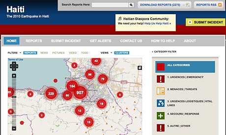
Haiti map on Ushahidi.com
Haiti map on Ushahidi.com, built using OpenStreetMap data

If you want to find an up-to-date map of Haiti, then there is only one place to go. It is not Google Maps or any of its competitors. It is the admirable OpenStreetMap.org (OSM), which is being updated even as I write by volunteers all over the world.

It is the Wikipedia of the mapping world, and is used by millions of people. Started a little over five years ago in London by Steve Coast, it has steadily built up its database to the point where most of the world has now been mapped by a formidable team of volunteers which is doubling every six months: there were 212,000 at the last count, of whom 10% are active during any one month. At the end of January there were 239 people rebuilding the map of Haiti. For a bird's eye view of operations, go to the Ushahidi site.

When the earthquake happened it was a signal for OSM members around the globe to start downloading satellite images (either freely available or donated by Yahoo) and then to start tracing the outlines of streets on top so a map emerged. Volunteers on the ground in Haiti, often using Garmin GPS locators, added vital local information – such as which roads were passable, where the hospitals were situated, where refugee camps were, or walls, pharmacies, hedges and so forth – so rescue workers had an invaluable tool. The result is a new, detailed map that is updated frequently, unlike most commercial maps.

This is only one of a number of open projects operating in Haiti in what may come to be seen as a seminal moment in the harnessing of the web to help those in need. Others include CrisisCommons, WeHaveNeed, Sahana, open source medical software and numerous others, not to mention Twitter tags such as #haiti. One of the problems of using appropriate technology in disaster regions is that bricklayers in Haiti don't know of innovations that might have been pioneered in remote parts of Africa, a problem that Akvo is trying to solve with regard to water. There are also signs that Hexayurt low-cost housing projects are starting to seed in Haiti.

OpenStreetMaps is itself at a turning point as it tries to progress from a techie-driven project to one that the ordinary consumer can not only understand but contribute to as well. It suffers from what might be dubbed "open source syndrome", a complaint that also affects other OS projects including the Linux operating system – the involvement of skilled volunteers can make the early stages a bit difficult to understand for laypeople.
However, they have been working on it and it is now much easier to do. A few days ago I added my local curry house to the map (next to a post box someone else had already inserted). All I needed to do was to drag a symbol of a restaurant from the bottom of the screen to where I wanted to put it and then add the words "Indian Diner". That in a nutshell is the comparative advantage that OpenStreetMap claims over other online maps. Users can add whatever detail interests them such as cycle routes, skateboarding areas, cycle parks, paths through parks – the parts Google can't reach. You have to register (it's free) as a member to alter the map. There is an iPhone app, Mapzen, produced by Cloudmade (company founded by Coast and Nick Clark to exploit mapping opportunities) that enables you to insert places of interest you have found on the move. If that takes off, it could lift the project to a new level.

Often volunteers create maps where there was nothing before as in Kibera in Kenya where basic amenities such as drinking water sources and latrines as well as churches are located to improve living standards and combat illness (eg, where latrines are located too near water sources). The Kibera team have been asked by Ushahidi and Google to include mapping of the slums of Port-au-Prince as part of the relief effort, something that hasn't been done before.

Gordon Brown, the UK prime minister, has just rediscovered cooperativism as a way of galvanising people to vote Labour. He would have been much more in tune with the times if he had widened it to include the open source movement in all its different aspects. It is one of the most interesting phenomena of our times, a kind of global mutual society. While the likes of Apple and Amazon, though producing fantastic products, are becoming ever more controlling and proprietary, it is sobering to be reminded that one of the basic instincts of human nature – mutual cooperation for no cost – is thriving on a global scale.

Follow Vic Keegan on Twitter

Monday, August 10, 2009

Odd tricyle mapping Paris streets for Google

August 7th, 2009 By HELENE GOUPIL , Associated Press Writer Odd tricyle mapping Paris streets for Google (AP)

Enlarge

Google employee Arthur Poirier, on a camera-equiped tricycle, records images for Google's Street View Maps in front of the Grande Arche de la Defense, outside Paris, Friday, Aug. 7, 2009. The U.S. company has hired two young cyclists to ride through gardens, historical sites and other pedestrian-only areas on the three-wheeler to take thousands of digital photos. (AP Photos/Jacques Brinon)

(AP) -- Parisians and tourists, relax. That goofy looking tricycle equipped with loads of high-tech equipment roaming the streets is NOT some mad scientist's invention on the rampage.

The three-wheeler is a sight with its long pole holding nine cameras, a GPS, a computer and a generator. But the contraption tooling around the French capital needs all that gear to do its job - adding three-dimensional images to Google's Maps.

The U.S. company has hired two young cyclists to ride through gardens, historical sites and other pedestrian-only areas on the device to take thousands of digital photos.

"The idea is to be able to offer 360-degree images of places that were inaccessible before," Google spokesperson Anne-Gabrielle Dauba-Pantanacce said in an interview.

The riders, wearing Google tee-shirts and white helmets, are visiting well-known sites such as the Chateau de Versailles, west of Paris, the Jardin du Luxembourg on the city's Left Bank or Les Halles, in the busy center of the French capital.

Google is to map Paris until Aug. 20, then head to the north of the country. In the fall, the tricycle goes south, said Dauba-Pantanacce.

The company plans to add new photos to their Street View option in all French cities with touristic areas that may be of interest to visitors.

Similar tricycles have already combed the streets of Britain and Italy in June and July, said Dauba-Pantanacce. Google plans to make 3-D maps of streets in other European countries, but the schedule has not yet been set, she said.

Spotted Friday at La Defense, the tricycle looked decidedly out of place at the modern high-rise business center on Paris' western edge.

A clunky white pole in the back holds an octagonal platform with eight cameras on the sides and one on top. Each minute, the cameras take bursts of high-definition photos to allow online users to get a virtual tour of the area.

"I rode two hours this morning," said 25-year-old Gregory Landais, who was taking a break after cruising through La Defense, France's touch of Manhattan. "For a site like this, it can take up to five hours."

To respect people's privacy, Google has installed software that recognizes license plates and people's faces and automatically blurs them, Dauba-Pantanacce said. Google will then choose the best photos among the thousands taken.

The blurring comes to meet privacy concerns.

Google recently acceded to German demands to erase the raw footage of faces, house numbers, license plates and individuals who have told authorities they do not want their information used in the service.

Greek officials rejected a bid to photograph the nation's streets until more privacy safeguards are provided. Residents of one English village formed a human chain to stop a camera van, and in Japan the company agreed to reshoot views taken by a camera high enough to peer over fences.

The photos of and other major French cities to follow were expected to be available online by the end of the year.

One curious sightseer was 46-year-old Jose Mountinho of Portugal.

"I've already seen Maps but I had no idea how they did it," Mountinho said.

---

http://www.google.com/intl/fr/press/streetview/index.html )

http://maps.google.fr/

©2009 The Associated Press. All rights reserved. This material may not be published, broadcast, rewritten or redistributed.